


The Sacred Bridge: Carta’s Atlas Of The Biblical World
The Sacred Bridge: Carta’s Atlas Of The Biblical World
SKU: PB401
Couldn't load pickup availability
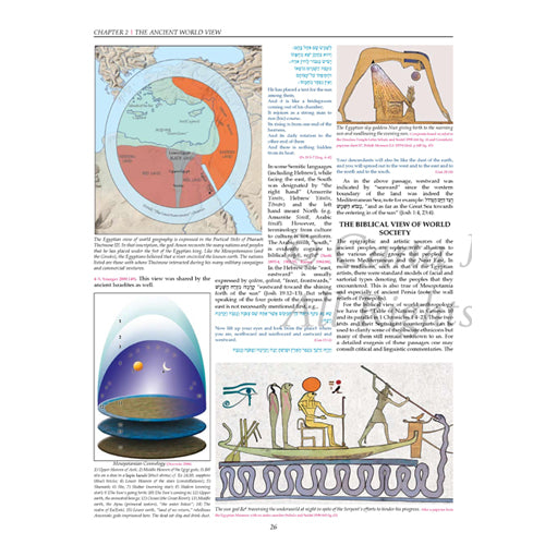
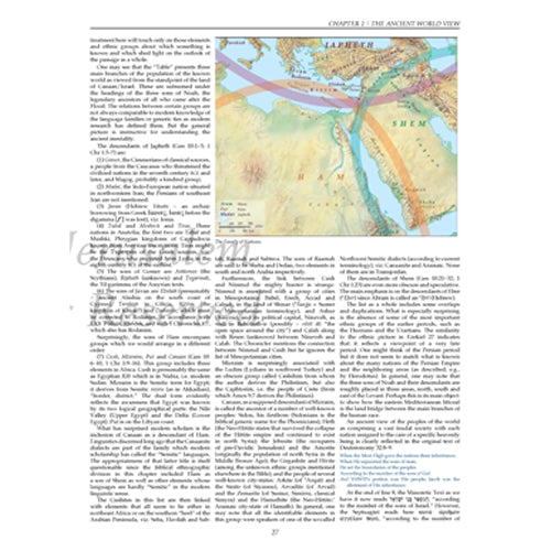
A wonderful book of Bible atlases! Documenting over 3,000 years of history, The Sacred Bridge is a depiction of Biblical history, geography, and archaeology that incorporates ancient Near Eastern sources into the narrative of the Atlas. This Bible atlas contains full-color maps, pictures, and diagrams that reflect 10 years of research. Every ancient extra-biblical passage is interpreted firsthand, from its native language. Up-to-date archaeological evidence has been included and explained wherever relevant.
Archaeological evidence has been taken into account whenever it is relevant. The logical geographical unit the “Levant” in spite of its lack of homogeneity in some physical and ecological respects is a land bridge that saw the influx of many races and ethnic groups. The chronological scope of this volume includes peoples of the third millennium BCE down to the Greeks, the Itureans, and the Nabateans in the Hellenistic and Roman periods. New Testament geography, especially that of the Gospels, is interpreted in light of new understanding resulting from discoveries such as the Dead Sea Scrolls. Refreshing insights serve to define geographical terms used in the New Testament.
Detailed references to the most recent scholarly works on ancient texts consulted and cited for each period of ancient history.
DO YOU KNOW THE ANSWERS? (FOUND IN THE SACRED BRIDGE)
1) What are the dimensions and disciplines of historical geography?
2) Who were the ‘Apîru and why did Prof. Rainey consider them a social phenomenon?
3) Where is the real location of Bethel?
Find the answers to these and countless other questions relating to historical geography of the Bible in The Sacred Bridge: Carta's Atlas of the Biblical World.
Excerpt from Foreword:
"This atlas of Historical Geography of the Levant was originally conceived fifteen years ago but, dictated by previous commitments, the actual writing began only after the start of the third millennium. R. Steven Notley joined the project soon after. Efforts were almost ended before they had really begun, when Notley came within fifteen minutes of being beneath the Twin Towers at the time they were struck on 11 September 2001. Since then both of us have striven to complete this awesome task.
Every generation of Bible scholars makes its own contribution based on the knowledge, research, and wisdom of preceding generations. This volume is no exception. Within its pages, we have endeavored to provide the reader with state-of-the-art information and to demonstrate how research in historical geography really works."
Contents:
- Dimensions and Disciplines
- The Ancient World View
- The Land Bridge
- The Dawn of History
- Amorite Dominance
- Conquest and Confrontation
- The Amarna Age
- The Ramesside Age
- Crisis and Transition
- Survival and Renewal
- Territorial States
- Regional Conflicts
- Window of Opportunity
- Imperial Domination
- Crisis and Turmoil
- Persian Domination
- Alexander and the Early Hellenistic Period
- The Hasmonean Struggle for Independence
- The Hasmonean Kingdom
- Hasmonean Decline and The Rise of Herod
- Herod and His Sons
- Historical Geography of the Gospels
- The Early Days of the Church
- The First Jewish Revolt Against Rome
- The Bar Kochba Revolt
Anson F. Raniey (1930-2011), Th.M., Ph.D., was emeritus professor of Ancient Near Eastern Cultures and Semitic Linguistics at Tel Aviv University, adjunct professor of Historical Geography at Bar Ilan University and the American Institute of Holy Land Studies.
R. Steven Notely, Ph.D., is a distinguished professor of Biblical Studies at the New York City campus of Nyack College and former Chairman of the Department of New Testament Studies, American Institute for Holy Land Studies. Professor Notley, who is at the cutting edge of modern New Testament research, combines his philological training with an intimate firsthand knowledge of biblical geography.
Shmuel Ahituv, Ph.D., is emeritus professor of Bible and Ancient Near Eastern Studies at Ben-Gurion University of the Negev. He has written several books, his latest the monumental Echoes from the Past: Hebrew and Cognate Inscriptions from the Biblical Periods. Years of experience as co-editor of the Board of Editors for the prestigious Encyclopedia Miqra'it (Encyclopedia Biblica) give Prof. Ahituv the unique ability to edit and critique such a work as this Atlas. His work in Hebrew inscriptions and his acquaintance with ancient Egyptian make him especially qualified to serve as the Academic Editor.
Language: English
Hardcover
448 pages
9.5 x 13.5 in. (24 x 34 cm)
Featuring: Maps, Illustrations, Photographs, Full Color, Chronological Table, Index, Bibliography
Weight: 2.05 kg (4.5 pounds)
Additional Information
Additional Information
Share